Title and statement of responsibility area
Titel
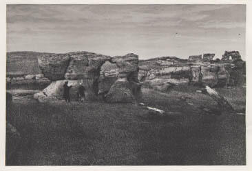
La Roche Percee - Mouse River
Algemene aanduiding van het materiaal
- Graphic material
Parallelle titel
Overige titelinformatie
Title statements of responsibility
Titel aantekeningen
Beschrijvingsniveau
Stuk
archiefbewaarplaats
referentie code
INS-782
Editie
Editie
Edition statement of responsibility
Class of material specific details area
Statement of scale (cartographic)
Statement of projection (cartographic)
Statement of coordinates (cartographic)
Statement of scale (architectural)
Issuing jurisdiction and denomination (philatelic)
Datering archiefvorming
Datum(s)
-
ca. 1878 (Vervaardig)
Fysieke beschrijving
Fysieke beschrijving
2 negatives : b & w ; 7 x 6 cm (each)
1 photograph : b & w ; 12.5 x 8.5 cm
Publisher's series area
Title proper of publisher's series
Parallel titles of publisher's series
Other title information of publisher's series
Statement of responsibility relating to publisher's series
Numbering within publisher's series
Note on publisher's series
Archivistische beschrijving
Naam van de archiefvormer
Geschiedenis beheer
Bereik en inhoud
"La Roche Percee - Mouse River - Plate facing page 94 in - 'Reports Upon the Survey of the Boundary Between the Territory of the United States and the Possessions of Great Britain from the Lake of the Woods to the Summit of the Rocky Mountains' Dept of State, Washington, Gov't Printing Office, 1878."
Aantekeningen
Materiële staat
Directe bron van verwerving
Ordening
Taal van het materiaal
Schrift van het materiaal
Plaats van originelen
Beschikbaarheid in andere opslagformaten
Restrictions on access
There are no restrictions on access.
Termen voor gebruik, reproductie en publicatie.
Photographer: Unknown
Copyright holder: Public domain
Copyright expires: Public domain
Other terms: Responsibility regarding questions of copyright that may arise in the use of any images is assumed by the researcher.

