Área de título y declaración de responsabilidad
Título apropiado
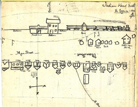
Hand-drawn map/sketch of Indian Head in 1882
Tipo general de material
- Graphic material
Título paralelo
Otra información de título
Título declaración de responsabilidad
Título notas
Nivel de descripción
Item
Institución archivística
Código de referencia
Área de edición
Declaración de edición
Declaración de responsabilidad de edición
Área de detalles específicos de la clase de material
Mención de la escala (cartográfica)
Mención de proyección (cartográfica)
Mención de coordenadas (cartográfica)
Mención de la escala (arquitectónica)
Jurisdicción de emisión y denominación (filatélico)
Área de fechas de creación
Fecha(s)
Área de descripción física
Descripción física
Hand-drawn sketch/map: b&w; 18 x 24 cm
Área de series editoriales
Título apropiado de las series del editor
Títulos paralelos de serie editorial
Otra información de título de las series editoriales
Declaración de responsabilidad relativa a las series editoriales
Numeración dentro de la serie editorial
Nota en las series editoriales
Área de descripción del archivo
Nombre del productor
Historia biográfica
Edwin Jackson Brooks was born in Lennoxville, Quebec, in 1949. He and his twin brother Edward arrived in July, 1882 and chose land just west of Indian Head, only to be told that the land had already been reserved by the Qu'Appelle Valley Company (Bell Farm). He later chose land north of Indian Head (Wide Awake District). He became a prominent citizen and merchant in Indian Head. In 1885, he was selected to serve on the jury for the trial of Louis Riel.
Historial de custodia
Alcance y contenido
Sketch/map by Edwin J. Brooks of the CPR station and buildings along the railway - all labelled. A path (later Grand Avenue) goes to the northwest and is labelled "To Bell..."
Área de notas
Condiciones físicas
Origen del ingreso
Arreglo
Idioma del material
Escritura del material
Ubicación de los originales
PS2
Disponibilidad de otros formatos
Restricciones de acceso
Condiciones de uso, reproducción, y publicación
Instrumentos de descripción
Materiales asociados
Acumulaciones
Nota general
The sketch was before Indian Head was a town and so the only street, labelled Main Street, is actually North Railway Avenue - possibly the easterly part being present-day Main Street, which currently begins at the corner of Grand Avenue and North Railway Avenue and proceeds northeasterly..
Reverse: "Main Street 1882. Copy of sketch map drawn by E.J. Brooks for his wife on Nov. 16, '82. Vital Statistics: Stores = 3, Hotels = 3, Tents = 8, Bakery = 1,Laundry = 1, Houses = 4, Livery barn = 1. All strung along the newly laid track, opposite the old station and freight shed."
Identificador/es alternativo(os)
Área de número estándar
Número estándar
Puntos de acceso
Puntos de acceso por materia
Puntos de acceso por lugar
Puntos de acceso por autoridad
- Brooks, Edwin Jackson (Materia)