Title and statement of responsibility area
Title proper
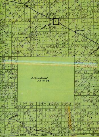
Early 1900s Land Title Map
General material designation
- Textual record
Parallel title
Other title information
Title statements of responsibility
Title notes
Level of description
Item
Repository
Reference code
IHM.2020.0364
Edition area
Edition statement
Edition statement of responsibility
Class of material specific details area
Statement of scale (cartographic)
Statement of projection (cartographic)
Statement of coordinates (cartographic)
Statement of scale (architectural)
Issuing jurisdiction and denomination (philatelic)
Dates of creation area
Date(s)
-
[190-?] (Creation)
Physical description area
Physical description
1 map ; 44 x 28 cm
Publisher's series area
Title proper of publisher's series
Parallel titles of publisher's series
Other title information of publisher's series
Statement of responsibility relating to publisher's series
Numbering within publisher's series
Note on publisher's series
Archival description area
Custodial history
Loaned by LaJoan Willioughby on July 22, 2020
Scope and content
A green land title map covering the grid from Rge.10 Twp. 15 to Rge.12 Twp. 18. Within the grid are the towns of Sintaluta and Wolseley as well as Carry The Kettle (Ce-Ga-Kin) Reserve .
Notes area
Physical condition
Immediate source of acquisition
Arrangement
Language of material
Script of material
Location of originals
Returned to donor. Scanned copy is at C:Documents/Archived Accessions/Scanned Copies/IHM.2020.0364.tiff
Availability of other formats
Restrictions on access
Terms governing use, reproduction, and publication
Finding aids
Associated materials
Accruals
General note
The museum was not donated the original map. It was scanned with the donor's permission and a hard copy was printed and laminated.
Location note
B13
Alternative identifier(s)
Standard number area
Standard number
Access points
Subject access points
Place access points
Name access points
- Willioughby, LaJoan (Subject)