Zone du titre et de la mention de responsabilité
Titre propre
Department of Archaeology - Excavations
Dénomination générale des documents
- Document graphique
Titre parallèle
Compléments du titre
Mentions de responsabilité du titre
Notes du titre
Niveau de description
Pièce
Cote
Zone de l'édition
Mention d'édition
Mentions de responsabilité relatives à l'édition
Zone des précisions relatives à la catégorie de documents
Mention d'échelle (cartographique)
Mention de projection (cartographique)
Mention des coordonnées (cartographiques)
Mention d'échelle (architecturale)
Juridiction responsable et dénomination (philatélique)
Zone des dates de production
Date(s)
-
[ca. 1967] (Production)
Zone de description matérielle
Description matérielle
1 photograph : b&w ; 17.7 x 12.7 cm
Zone de la collection
Titre propre de la collection
Titres parallèles de la collection
Compléments du titre de la collection
Mention de responsabilité relative à la collection
Numérotation à l'intérieur de la collection
Note sur la collection
Zone de la description archivistique
Nom du producteur
Historique de la conservation
Portée et contenu
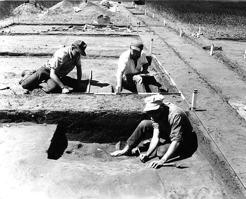
Donald Welsh, Dave Meyer and Hugh MacKie, working on an archaeological dig at Fort Riviere Tremblante near Kamsack, Saskatchewan.
Bio/Historical Note: Fort de la Rivière Tremblante (also called "Fort Tremblante", "Aspin House" and "Grant's House") was a trading post of the North West Company on the Assiniboine River from 1791 to 1798. It was in prime fur country and produced most of the beaver and otter pelts in the Assiniboine district. Many of the furs likely came from the forested area to the east that is now Duck Mountain Provincial Park (Saskatchewan). It was founded by Robert Grant in 1791 and from 1793 to 1798 Cuthbert Grant Sr was in charge. His more famous son was born here in 1793. It was closed in 1798 and burned down in 1800. It was located about 9 miles south southeast of Kamsack, Saskatchewan and west of Togo, Saskatchewan. It was located 500 paces east of the Assiniboine just above the mouth of the Rivière Tremblante which comes in from the east. Fort de la Rivière Tremblante was excavated by Hugh MacKie, a University of Saskatchewan archaeologist, in the summers of 1967 and 1968. This work demonstrated that it was a solidly built establishment with several episodes of construction as it was expanded through the years.
Zone des notes
État de conservation
Source immédiate d'acquisition
Classement
Langue des documents
Écriture des documents
Localisation des originaux
Disponibilité d'autres formats
Restrictions d'accès
Délais d'utilisation, de reproduction et de publication
Copyright: University of Saskatchewan

