Aerial view of northern Baffin Island
- WOK 20-4
- Item
- 1965
Part of W.O. Kupsch fonds
Citation reads: "Aerial view of nice cap in distance, fiords in foreground, northern Baffin Island, August 16, 1965."
717 results directly related Exclude narrower terms
Aerial view of northern Baffin Island
Part of W.O. Kupsch fonds
Citation reads: "Aerial view of nice cap in distance, fiords in foreground, northern Baffin Island, August 16, 1965."
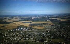
Aerial view of northwest quadrant of Lloydminster
Part of LRA Photograph Collection
View of Northwest portion of Lloydminster with the old Catholic Church in foreground
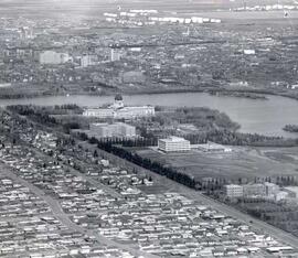
Aerial view of Regina looking northeast
Part of City of Regina fonds
Aerial view looking northeast over the city. The Legislative Buildings, Wascana Lake and Campion College are seen in foreground. From Thornton Avenue to outer city limits (north), Rae Street to east edge of Wascana Park.
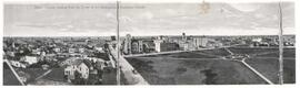
Aerial view of Regina, Saskatchewan
Part of City of Regina fonds
The City of Regina as seen from the top of the Metropolitan Methodist Church. Victoria Park is visible in the left of the frame. Little landscaping has been done to the park.
Aerial view of settlement, Aklavik, N.W.T.
Part of W.O. Kupsch fonds
Citation reads: "Aerial view of settlement, Aklavik, N.W.T. August 22, 1965."
Aerial view of settlement, Inuvik, N.W.T.
Part of W.O. Kupsch fonds
Citation reads: "Aerial view of settlement, Inuvik, N.W.T. August 22, 1965."
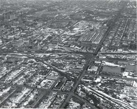
Aerial view of the CP rail-yards and warehouse districts
Part of City of Regina fonds
Rail-yards and warehouse district from the air. From Broad Street to Broder Street, Arcola Avenue to outer city limits (north).
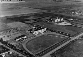
Aerial view of the hospital and nurses residence
An aerial view of the Rosetown Hospital and adjacent nurses residence with St. Joseph's convent beside them.
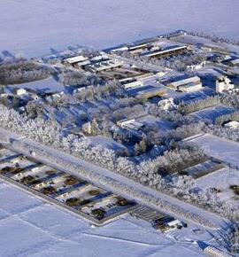
Aerial View of the Melfort Research Farm
Part of Melfort General Photo collection
An aerial view of the Melfort Research Farm in the winter time.
Aerial View of The Rural Municipality of Biggar #347
Part of Biggar Photograph Collection
An ariel view of TW33/34 RG 12/13 in the Rural Municipality of Biggar # 347
Royal Canadian Air Force (R.C.A.F.)
Aerial View of The Rural Municipality of Biggar #347
Part of Biggar Photograph Collection
An ariel view of TW33/34 RG 13 in the Rural Municipality of Biggar # 347
Royal Canadian Air Force (R.C.A.F.)
Aerial View of The Rural Municipality of Biggar #347
Part of Biggar Photograph Collection
An aerial view of TP 33/34 RG 14 in the Rural Municipality of Biggar # 347
Royal Canadian Air Force (R.C.A.F.)
Aerial View of The Rural Municipality of Biggar #347
Part of Biggar Photograph Collection
An aerial view of TP 34 RG 14 in the Rural Municipality of Biggar # 347
Royal Canadian Air Force (R.C.A.F.)
Aerial View of The Rural Municipality of Biggar #347
Part of Biggar Photograph Collection
An aerial view of TP 34 RG 14/15 in the Rural Municipality of Biggar # 347
Royal Canadian Air Force (R.C.A.F.)
Aerial View of The Rural Municipality of Biggar #347
Part of Biggar Photograph Collection
An aerial view of TP 33/34 RG 16 in the Rural Municipality of Biggar # 347
Royal Canadian Air Force (R.C.A.F.)