- All
- Biggar, Rural Municipality No. 347 (Sask.), 252 results
- Regina (Sask.), 19 results
- Moose Jaw (Sask.), 17 results
- Biggar (Sask.), 14 results
- Rosetown (Sask.), 10 results
- Melfort (Sask.), 8 results
- Wascana Lake (Sask.), 5 results
- Lloydminster District, 5 results
- Lloydminster (Sask.), 4 results
- Indian Head (Sask.), 4 results
Aerial views
Taxonomie
Code
Bereik aantekeningen
ron aantekeningen
Toon aantekening(en)
Hiërarchische termen
Aerial views
Gelijksoortige termen
Aerial views
Verwante termen
Aerial views
717 Archival description results for Aerial views
717 results directly related Exclude narrower terms
- PAS-001-a
- Bestanddeel
- 1930-1961
Part of Prince Albert Sanatorium fonds
File contains aerial photographs of the Prince Albert Sanatorium.
Zonder titel
Fort San Building Image Collection
- FS-004
- Reeks
- 1917-1971
Part of Fort San fonds
Collection contains exterior and interior images of the Fort San Sanatorium.
- A-198
- Stuk
- summer 1957
View looking northeast of campus. Road to President's Residence running along bottom of image; University Hospital at centre. Saskatchewan Research Council building under construction in background centre; University lands and Sutherland also in background.
- A-5654
- Stuk
- July 1960
View looking southeast across campus, with the Bowl at centre.
- A-5676
- Stuk
- July 1960
View looking northwest across campus, with the Bowl at centre. Varsity view homes, Griffiths Stadium and College Drive running along bottom of image.
- A-776
- Stuk
- [1954 or 1955]
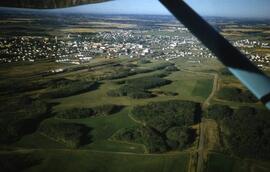
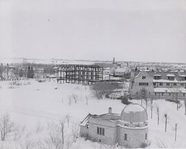
Aerial view looking northeast of the Observatory in winter. Construction of the Memorial Union Building at centre; Emmanuel College at right.
Bio/Historical Note: The Observatory was designed by Gentil J.K. Verbeke and constructed in two phases using local limestone from 1928-1930 for about $23,000. The R. J. Arrand Contracting Co. was contracted to build the Observatory Tower in 1928 for a cost of $6625. The firm completed the tower $353 under budget on 14 April 1929, for $6,272. On 20 June 1929 R. J. Arrand was again awarded a contract by the University, this time to build the small classroom wing of the Observatory for $15,640. Work on the classroom wing was completed on 23 January 1930 for $15,034.50. University funding for the construction of the building was supplemented by private donations. Along with the Field Husbandry Building, the Observatory would be among the last free-standing buildings constructed on campus until after World War II. A plaque with the names of many donors still hangs inside the dome of the observatory. Saskatoon residents will find many of the names highly recognizable even today. A sundial was added to the exterior of the Observatory during the 1940s. It reads:
I am a Shadow
So art thou
The observatory facilities are available for use by both university students and visitors to the campus. The telescopes and other scientific equipment are used by students during the laboratory component of their courses. University personnel regularly offer tours of the observatory to elementary and high school classes, youth groups and other community associations. The Observatory is staffed year-round on Saturday nights so that any visitor may view celestial objects through the telescope.
- A-9984
- Stuk
- July 1970
View looking east with Education Building and Arts Tower in foreground; University lands and east side residential areas in background.
- A-10006
- Stuk
- Aug. 1971
View of campus looking northeast; east side residential area, 25th Street Bridge and South Saskatchewan River in foreground. Campus building at centre of image, with College Drive intersecting image.
- A-10009
- Stuk
- Aug. 1971
View of campus looking west; Preston Avenue runs along bottom of image, with campus buildings at centre. East side residential area visible, with College Drive running along left side of image. 25th Street Bridge, river and west side in background.
- A-10074
- Stuk
- Sept. 1979
View looking northeast of campus buildings, with the Bowl at centre.
- A-10075
- Stuk
- Sept. 1979
View looking north of campus buildings, with College Drive running along bottom of image. Prairie fields and Preston Avenue in background.
- A-10276
- Stuk
- summer 1967
View of campus looking northeast with President's Residence and College Drive in foreground. University Hospital at centre of photograph; surrounding campus buildings and prairie in background.
- A-10281
- Stuk
- summer 1967
View looking northeast with Arts-Commerce-Law Complex Building at centre; Health Sciences Building in foreground.
- A-10285
- Stuk
- July 1970
View looking east with riverbank and University Hospital visible along bottom of image. Arts Tower Building at centre; College Drive and University lands in background.