- A-9725
- Item
- May 1969
View looking northwest with campus buildings and College Drive in foreground. River and west side residential districts in background.
717 results directly related Exclude narrower terms
View looking northwest with campus buildings and College Drive in foreground. River and west side residential districts in background.
View looking southwest with Preston Avenue and University land in foreground; the Bowl and Arts Building with surrounding buildings at centre.
Looking southwest across campus with Crop Development Centre in foreground; College Drive running through at centre.
View of campus with Innovation Place, farm land and CPR and Circle Drive Bridges visible.
View looking east across campus with the Bowl at centre.
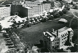
View looking east with Arts and Chemistry buildings and the Bowl in foreground. Other buildings visible are Marquis Hall and St. Thomas More College additions.
View looking east with University Hospital in foreground; the Bowl and surrounding buildings at centre.
View looking east with University Bridge and South Saskatchewan River in foreground, campus buildings at centre.
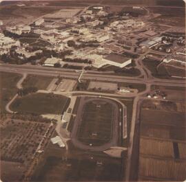
Looking north with Griffiths Stadium in foreground, College Drive running through at centre, and campus buildings in background.
Looking west at University (Main) Barn in foreground; Engineering Building and surrounding buildings at centre.
Looking east with Health Sciences Building in foreground and Murray Memorial (Main) Library at centre.
Looking northeast at St. Andrew's College and Little Stone School in foreground; University Hospital at upper left.
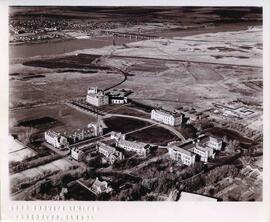
Looking northwest with University Hospital at centre of image.

Looking west at Main Barn at centre; Chemistry Building, Administration Building, and other campus buildings also visible. College Drive runs at bottom left.
Looking northeast at campus with the Bowl at centre with surrounding buildings; tennis courts at far left.